

[UPDATE KEY: verified, disproven, new.
This is my off-the-cuff theory: the ship was heavily modified (see pictures), and was subsequently overloaded (conjecture). Heavy seas and high winds (various reports) contributed to the instability. The ship, probably ungainly even in a calm sea, in the bad weather was moving enough that some vehicles broke free and began sliding around, becoming a serious free weight issue (conjecture). Perhaps passengers assembled on one side of the ship for some reason (conjecture).
The ship seems to have gone down in nearly an instant, as in the first few hours, there have been no reports of an SOS call. There are reports that an SOS call was received by the crew of M/V Saint Catherine, which is owned by the same company, and was travelling the opposite direction on the same route when Al-Salam-98 went down. If there were no SOS calls received by alert stations on either side of the Red Sea, then the distress calls were probably made only on VHF Channel 16, which is limited to line-of-sight. This also constrains the time of the call–if I can determine the schedule of Saint Catherine, we can nail the point where they distress call was made to within perhaps 30NM by 10NM. At any rate, the Captain of Saint Catherine has said that he opted not to return to assist Al-Salam-98, as he believed that this would hazard his vessel and passengers, due to the danger of coming about (turning around) in such bad weather. MORE ON THIS LATER.
Also, reports have said that the ship “disappeared from radar”, and no mention has been made of the ship stopping for a length of time before disappearing. This disappearance from radar always sounded a little odd to me, and here’s why: Duba, Saudi Arabia, and Safaga, Egypt (the departure and arrival ports) are about 120 nautical miles apart, athwart the Red Sea. The voyage was scheduled for an eight hour duration, so the ship should have averaged perhaps 15 knots (nautical miles per hour). If the ship disappeared from Duba’s radar by sinking, it would have done so sooner in the journey, and if from Safaga, then later. Numerous newspaper articles cite “officials at the Maritime Control Center in Suez” as saying that the ship disappeared from radar shortly after depating. XINHUA even gives the information as “disappeared from radar screens off the Saudi Coast”. We won’t pick on their grammar here. BBC produced a graphic which shows the area about 30NM from Safaga, but cites 56NM as the distance–I will assume that the graphic is mistaken. We may also probably assume a radar station at Sharm el-Sheik, the southern tip of the Sinai Peninsula. The only justification I have for this is that it looks like a great place for a radar station. A straight-line route passes just over 60NM from Shram el-Sheik, so this places the location of the sinking about 60 NM from THREE radar stations. Halfway through a successful journey from Duba to Safaga, a ship will have a radar 60 miles behind at Duba, another 60 miles ahead at Safaga, and a third 60 miles off to the right, north at Sharm el-Sheik. If the ship had disappeared from radar at the time of sinking, then with height-of-eye, direction of sea swell, and other unknowns being equal, the ship whould have disappeared from three radars, manned by three different sets of operators. Three reports would have gone to the Maritime Control Center in Suez. Instead, there was only one report, from Duba, the departure port. Alarm bells would have rung, perhaps literally, and the national rescue apparatus would have swung into action, rather than waiting for the ship’s owners to meekly mention, hours later, that they had lost contact with one of their ships, and later still, suspected that the ship may have sunk. I conclude therefore, that the effective radar range (that night anyway) was somewhat less than 60NM, and that when M/V Al-Salam-98 “disappeared from radar” shortly after departure, that this was a normal occurrence, and no reports other than routine would have been sent anywhere. It seems that when the ship “disappeared from radar”, it had done so because it simply sailed beyond radar range.
Still, this is the dog that didn’t bark. While the port operators at Safaga and Duba probably do not exchange information about departures and arrivals, especially for regularly scheduled ferry runs, there must be *somebody* who was expecting that ship to show up on radar perhaps an hour before arriving at Safaga. That somebody would be the ship’s owner. While I do not expect that the owner or the CEO, or any high-level type would wake up early to double-check the early morning arrival of a daily ferry run, there must be employees of the owning company at the port of Safaga. Even if the mooring opeations are contracted to port workers, along with traffic-handling and whatever else may be needed, I find it inconceivable that there would be no company employee waiting for the ship to arrive.
Picture the scene–AT THIS POINT, I will stop to do research about the SAFAGA port.
Narrative continues below, abruptly.
This suggests that the ship was grossly overloaded to have gone down so quickly–once a critical roll angle was reached, it could have gone down in less than a minute as it filled with water, particularly if the topside modifications caused it to “snap roll” after the critical angle. As the ship seems to have been a vehicle ferry, it would have cavernous opening not far from the waterline even on the best of days. Perhaps electrical power was lost as the roll began, or the radio (or radio operator) incapacitated.
There was a fire aboard, only minutes after leaving port, but the Captain refused to return to port, and pressed on toward Egypt. This suggests to me that the lack of an SOS call may also have been ordered by the Captain, whose attitude until far too late seems to have been that the problem was under control. Another possibility is that the fire, which eventually raged out of control on the vehicle deck, destroyed the capability for radio communications, either directly, through burning power or signal wiring or equipment, or burning the space (“room”) where the radio operator would have worked, or indirectly by filling various spaces/passageways with smoke.
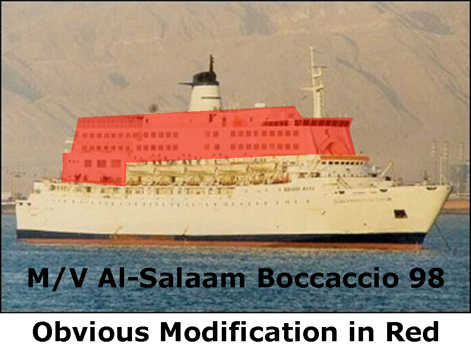
In the photographs above, I have identified the area which seems to be a modification (RED), adding a tremendous amount of topside weight, which reduces stability. Also, with the modification in place, a new bridge was built (B), with the old one remaining in place (A), perhaps as a lounge.
The possibility exists that neither of these pictures (as annoted) is accurate–perhaps the ship was built just the way it appears in these pictures, and the dark windows at the TOP (B) are a lounge or restaurant.
But I doubt it.
UPDATE: More pictures! From the ship’s builder, I believe. Built in 1971, the ship was rebuilt in 1991 before entering service for her new masters (1997?) on the Red Sea route.

Above: the ship as built, 1971.

Above: After 1991 Rebuild.